A Guide to Walking the Abel Tasman Coast Track

Hiking this beautiful Abel Tasman track does take a little bit of planning.
This guide contains all the advice you need to plan your own Abel Tasman walk, including how to get to the Abel Tasman National Park, staying in the Abel Tasman huts, what to consider when planning your track route (hello tides!), and what to expect on a four-day hiking itinerary.
One of New Zealand’s Great Walks, the Abel Tasman Coast Track is a great multi-day hike for any time of year.
With international travel currently off the table, this winter we decided to escape from the city to enjoy the Abel Tasman National Park without the crowds and make the most of the typically calm winter weather and views of the stunning turquoise water that the park is known for.
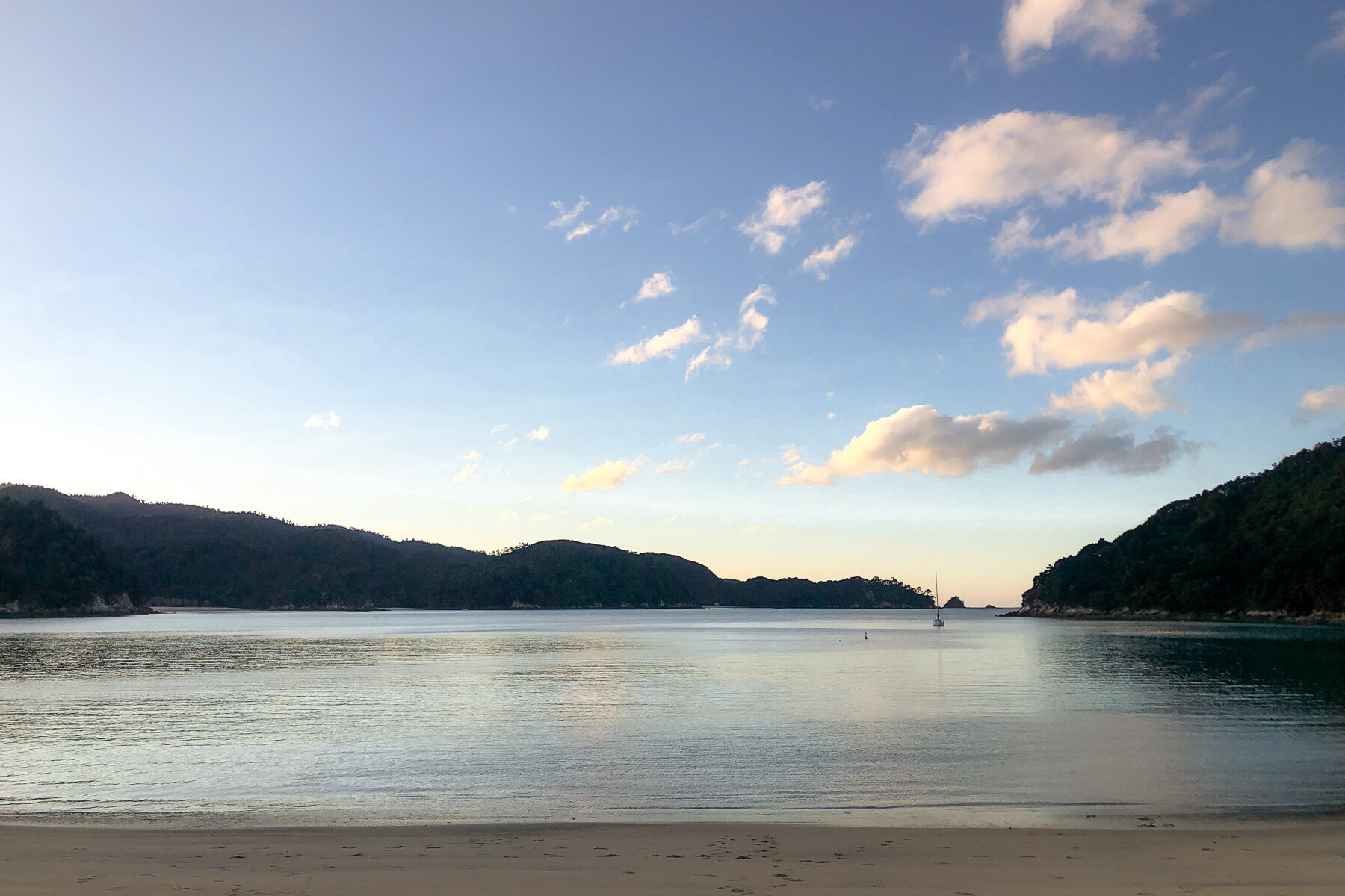
This coastal path, located about an hour’s drive from Nelson, passes from bay to bay through beautiful native bush and offers many opportunities to pause, relax and enjoy the serenity on deserted golden sand Abel Tasman beaches.
Whilst the full Abel Tasman track length is 60km, running from Mārahau in the south to Wainui in the north, there are endless options on where to start, how far to walk and where to stay on an Abel Tasman hike.
Based on my experience, here’s some advice and inspiration for planning your hike in the Abel Tasman National Park.
HOW TO GET TO THE ABEL TASMAN NATIONAL PARK
The Abel Tasman National Park is the smallest national park in New Zealand, but what it lacks in size, it more than makes up for in its amazing vistas and huge range of activities.
Along with the Abel Tasman Coast Track, the many other activities include kayaking, boating, camping, spotting seals, penguins and dolphins, mountain biking, or exploring some of the other hiking trails.
The national park is located at the top of the South Island, about an hour Northwest of Nelson near the town of Motueka.
ABEL TASMAN NATIONAL PARK MAP
Due to winter being off-season, and the impact of Covid-19 on the tourism industry in New Zealand, the options for public transport to the Abel Tasman National Park are more limited at this time,
» PUBLIC TRANSPORT TO ABEL TASMAN
Despite bus schedules being available online, no public buses have been running since February 2020.
» PRIVATE SHUTTLE OR TRANSFER TO ABEL TASMAN
Local operator Trek Express offer transfers to both the southern start/end point at Mārahau and the northern start/end point at Wainui. Over summer, these run daily per schedule, however over winter, trips are available only via charter. This is great option for a large group, and if you’re travelling on your own, they can advertise your trip for others to join which will help keep costs down.
» CAR RENTAL IN NELSON
There are many car rental options available in Nelson or Nelson airport and it’s an easy drive through orchards, wineries, hops farms and coastal towns. Once you arrive in the National Park, there are free Department of Conservation (DOC) carparks are available in Mārahau, Totaranui and Wainui, and water taxi operators also offer free parking for the duration of your hike if using their services.

View from the Waterfall Creek suspension bridge.
Whilst there are accommodation options in Mārahau or nearby in Kaiteriteri, it’s totally possible to arrive in Mārahau in the morning and complete the first leg of the hike in the afternoon.
We flew into Nelson airport early in the morning and decided to rent a car from there as it allowed us to make a few stops on the way through to Mārahau. We stopped for brunch at the epic The Smoking Barrel (you need to make space for at least one of their legendary donuts!) and to pick up a gas canister at the local Motueka outdoors store, as it’s not possible to bring these on the flight in.
On the way back to Nelson we also stopped in at some local craft breweries, such as Hop Federation which is conveniently located on the main road through Riwaka, and wineries, such as the award-winning Neudorf Winery (especially if you’re partial to a glass of chard like I am!) and picked up some well-earned treats to enjoy later.
Some other great places to visit between Nelson and the Abel Tasman National Park are Moturoa/Rabbit Island, a popular swimming beach accessed via a causeway off State Highway 60, and Kaiteriteri, a popular holiday spot with golden sandy beaches (tip: visit Little Kaiteriteri beach for a spot a little quieter than the main beach itself).

Torrent Bay, Abel Tasman National Park
THINGS TO CONSIDER WHEN PLANNING AN ABEL TASMAN ROUTE
With no set rules like some of the other Great Walks, the Abel Tasman Coast Track can be completed in either direction, and it’s totally possible to complete only a portion of the whole track. The distance covered each day can also vary to suit your preferences.
Abel Tasman Coast Track 5 days option - the traditional route, as detailed on the DOC website, starts at Mārahau and finishes at Wainui with a 5 day/ 4 night duration.
Abel Tasman Coast Track 3 days or 4 days options - combine the sections into longer days, or skip a leg.
Abel Tasman Coast Track 1 day option - complete just one section of the track, maybe combining the walk with a kayak from Mārahau to Anchorage.
The factors to consider when planning to hike Abel Tasman National Park:
» TRANSPORT WITHIN THE NATIONAL PARK
Shuttles can provide drop offs and pickups from both Mārahau and Wainui, however if you’ve travelled via car, you’ll probably want to start and end at the same place. To help you with that, there’s water taxis…
» ABEL TASMAN WATER TAXIS
these are an awesome option to get you to or from your starting point, but bear in mind that they only go as far north as Tōtaranui. This means if you want to complete the entire track from Mārahau to Wainui (or vice versa) you’ll need to complete a round trip from Wainui back to Tōtaranui via the Gibbs Hill Track to get picked up by the boat.
The water taxis operate on a fixed timetable, which is reduced over the winter months, so factoring in the first or last drop off time in important. Water taxis stop at most of the key beaches up to Tōtaranui and can be booked via their website or in the main store in Mārahau town before you start the walk.
» ABEL TASMAN COAST TRACK DURATIONS & DISTANCES
Staying in each of the huts will mean a walk of about 4 to 5 hours (or 10-15km) per day. If time is limited and your fitness level allows, it’s totally possible to combine sections together to complete the walk in less days.
Remember that in winter, daylight hours are limited and there may only be up to 10 hours of daylight per day. Whilst 4 or 5 hours of hiking per day isn’t as much as some of the other Great Walks, it provides many opportunities for a relaxing mid-day stop on a beach, or at one of the huts in the afternoon.
Anchorage Bay
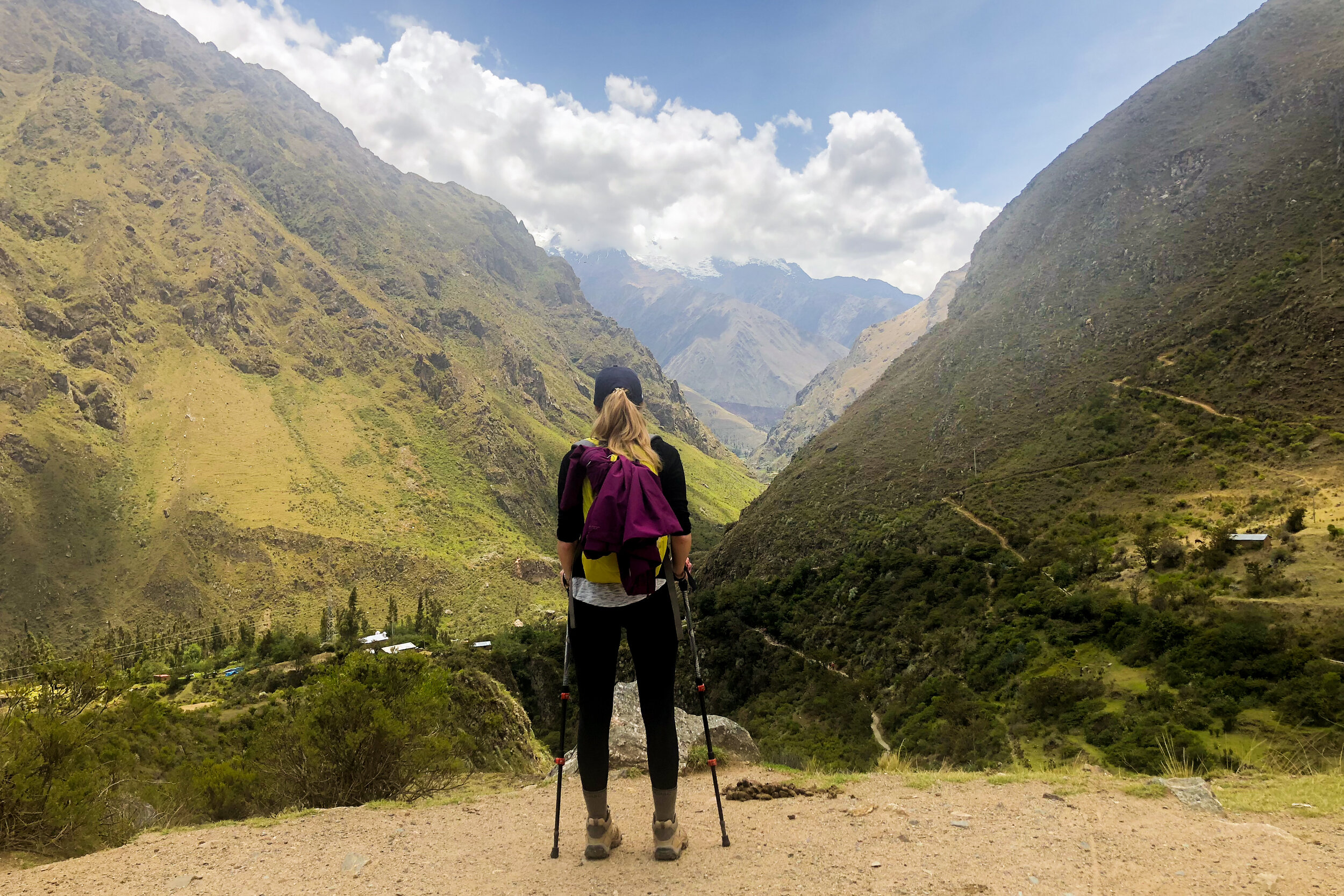
» TIDES ON THE ABEL TASMAN COAST TRACK
Knowing the tides is key to planning your route on the Abel Tasman Coast Track, as there are now four tidal areas to be aware of - and two of these don’t have alternative options - wet feet are required. The two tidal options with high tide routes are at Bark Bay and Torrent Bay. The two tidal areas that require planning are the famous Awaroa Inlet crossing and a new stream crossing the beach at Onetahuti Beach.
BARK BAY CROSSING //
This estuary can be crossed two hours either side of low tide, or take the high tide route around. Plan an extra 10 minutes for the high tide track.
TORRENT BAY CROSSING //
This estuary can also be crossed two hours either side of low tide, or take the high tide route which will add an extra hour (3km) to your journey.
AWAROA INLET CROSSING //
The Aware inlet crossing has no alternative option, crossing the inlet is required here. The inlet should only be crossed one and a half hours before low tide, or up to two hours after. The inlet takes about half an hour to cross and it should only be completed in daylight. The level of water can vary significantly even at low tide. It may become impassible after heavy rains or king tides so be sure to check the DOC website for warnings before starting your hike. We crossed the inlet after some rain and even though we were bang on low tide. The water reached mid-thigh height and there was a decent current but we made it through safely.
ONETAHUTI BEACH CROSSING //
This is a recently new obstacle on the track. A stream has diverted across the beach near the Onetahuti Beach camp, and unless you’ve got crazy longjump skills, you’ll need to wade a few metres across the shallow stream. This stream should be crossed within four hours each side of low tide, as it can reach 1.5m in depth.

Awaroa Inlet close to high tide
For example if you’re completing the track from north to south (from Whariwharangi to Awaroa) you should ensure low tide is from midday to afternoon, as you’ll need to complete about 5 hours of hiking before crossing the inlet.
If walking from south to north and you’ve stayed the night at Awaroa you should ensure the low tide is during the morning daylight hours, so that the inlet can be crossed before heading onwards to Tōtaranui to Whariwharangi.
As we would be hiking when low tide was about 5:30 in the evening, it worked out that we should head south and stay a night at Awaroa Hut after crossing the inlet, due to a lack of daylight after the crossing.
STAYING IN THE ABEL TASMAN HUTS
Accommodation in the huts or campsites can be booked on the Department of Conservation website and this needs be done in advance.
» HIGH SEASON
Over summer, the huts book out well ahead of time (key summer holiday dates will be gone as soon as reservations open in June for the season ahead!). Campsites will generally have more availability so can offer some flexibility to your schedule if walking during peak season.
» LOW SEASON
Over winter however, there’s generally really good availability in the huts. At both Awaroa and Bark Bay Huts, we had the place completely to ourselves, however we did have to adjust our itinerary as Whariwharangi Hut (the smallest hut on the track) was completely booked out the night we would have been there.
The other benefit of walking off-season is reduced hut fees! Huts are only $32/person/night in May/June/September and reduced down again to $26/person/night in July and August - and kids are free!
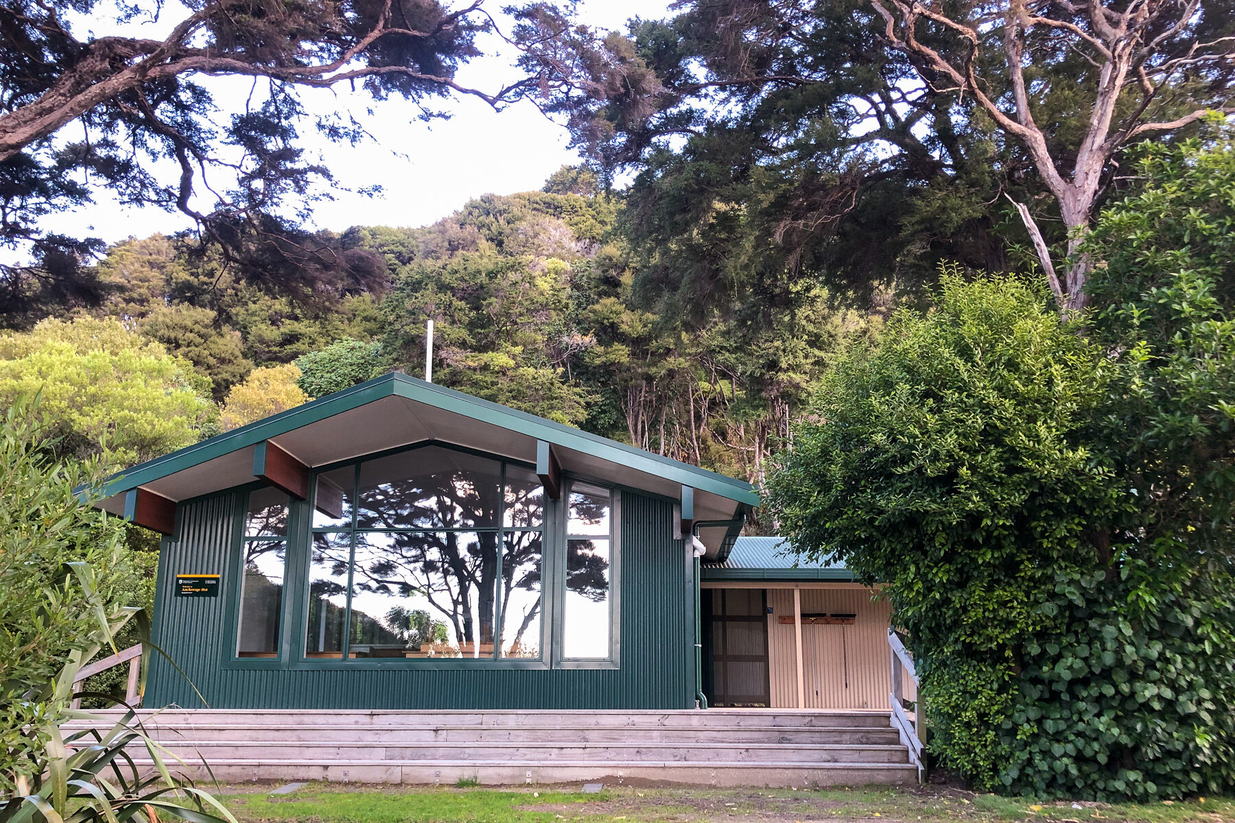
Anchorage Hut, Abel Tasman Coast Track
As this is one of the Great Walks, the hut facilities are some of the best in New Zealand. Along with mattresses and fireplaces, some of the huts even have wifi! There’s also flush toilets (including TP) and fresh water readily available.
Do note however that the water at Awaroa needed to boiled for three minutes before drinking, and none of the huts have cooking facilities at any time of the year - you will need to pack your own supplies including gas.
For more information on what to take on your hike, check out this article:
4 DAYS / 3 NIGHTS WALKING THE ABEL TASMAN COAST TRACK
The route we took for our hike was dictated by a few things:
Firstly, we had four days available for the hike. Secondly, the tides meant we would be crossing the Awaroa Inlet rather late in the afternoon. And thirdly, the Whariwharangi Hut was booked out the first night of our hut, so heading that direction wasn’t an option.
Therefore, we started our hike with a water taxi up to Tōtaranui and headed south back down to Mārahau.
Here’s our 4 day/3 night itinerary, with all distances and times (including lunch/photo stops) from my Garmin watch.
DAY 1 - TŌTARANUI TO AWAROA
» DISTANCE 7.5km
» TIME 2h 35m
» DIFFICULTY there were a couple of short sharp uphill and downhill sections, but otherwise pretty flat. A nice introduction to hiking with a full pack - though barefoot across the pipi shells wasn’t the most fun!
After catching an early morning flight into Nelson, picking up our rental car and driving North, we jumped aboard our water taxi about 1pm in the afternoon. As we were the only ones on the boat and there was no one to collect along the way, our friendly captain took us on the scenic route - a detour to check out famous Split Apple Rock (a must for every kayak adventurer) and a stop near one of the islands for some baby seal spotting. We were lucky to have the pups put on a show, playing around in the sunny rock pools.
After a bouncy ride through to Tōtaranui and a skilled beach landing by our talented captain, we had the entire beach to ourselves.
In fact, the only other hiker we would see that day was the one jumping on the boat to head back to Mārahau.

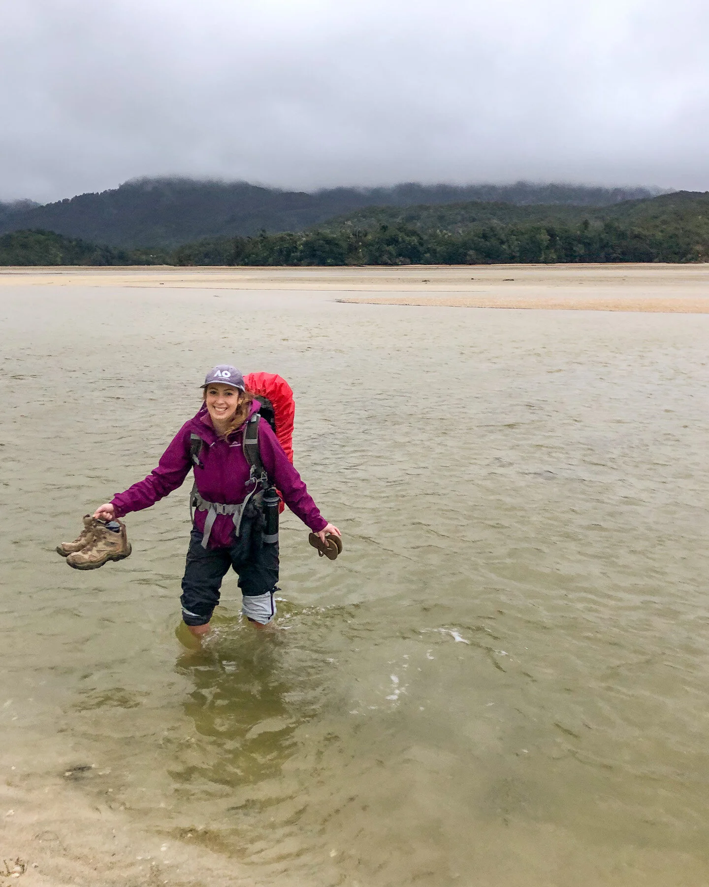
Completing a couple of hill climbs and a stint along the beautiful sands of Goat Bay, we emerged from the forest at the edge of the Awaroa Inlet. Low tide was fast approaching, and so were the low lying clouds that had been looming all afternoon. We spotted the hut way off in the distance and headed out across the muddy sand, keeping an eye on the orange markers that were hard to miss.
As we got further out into the estuary, keeping a straight line proved slightly more difficult as we tried to stick to the firmer/drier parts of the ground. Then finally, we had to make a decision, were we getting our boots wet or were they coming off?
Without knowing what fire supplies would be available at the hut, we decided a little pain now was better than being stuck in wet boots for the next three days, so off they came. Ouch. These not-yet-trail-hardened feet did not enjoy the crunch of the pipi shells, though the icy cold water helped to numb the pain!
As we approached the final water crossing, the storm was rolling in, daylight was fading fast, and it was hard to tell how deep the water actually was. But there was no turning back now, we had to get the hut. So thanking my lucky stars I’d packed my spare clothes and sleeping bag in a dry sack, in we went.
Halfway across, submerged to mid-thigh and the current still flowing out, I let out a sigh of relief, the water had started dropping down. As it retreated down to below my knees, I knew we had made it across.
We arrived to find Awaroa Hut completely empty! And even better, it was fully stocked with kindling and wood. After hanging out our wet gear and warming up with a comforting bowl of hot soup, we were ready to fall asleep - no earplugs required!

DAY 2 - AWAROA TO BARK BAY
» DISTANCE 14.75 km
» TIME 4h 55m
» DIFFICULTY generally flat with an uphill to start the day, and one just after lunch - the hardest battle was with the sandflies!
After waking to the sound of native birds, we sipped hot coffee while waiting for the rain to ease. Unfortunately, by mid-morning the weather still hadn’t cleared so we donned our wet weather gear and set off anyway. Saying goodbye to the hut, it was amazing to see the Awaroa inlet now full of water.
The track climbed up over Tonga Saddle where they should have been sweeping views over the beautiful Awaroa Bay. Due to the persistent rain, the outlook was a little muted but we could just imagine how brilliant the blue water would have looked on a sunny day. It was also pretty special to lay eyes on the beach that New Zealand bought - crowd funding managed to save the beach from developers, maintaining free access for us all.
Dropping down the other side of the saddle and along Onetahuti Beach, we arrived at the newest water crossing on the track. We found the shallowest point and took off our boots to cross the small stream. Spotting the Onetahuti Campsite a little further along, we headed for the camp shelter to have lunch out of the rain.
It was here that I quickly learned that the sandflies did not get scared away by the rain and cooler weather! By the time I’d dropped my pack and fished out some bandaids for a couple of blisters - the sandflies had already gone to lunch on my ankles. I didn’t even have time to grab the repellant!
As we headed over to Tonga Quarry, the sun had come out for the first time all hike, and we were treated to those beautiful blue waters that the Abel Tasman is so famous for. The tide was still high as we approached Bark Bay so we headed around the high tide track. Luckily, this treated us to our first swing bridge of the hike and it wasn’t long before we arrived at the Bark Bay Hut.
We’d passed two groups of hikers that day so thought we might have company at the hut, but again, it seemed the quiet off-season was living up to it’s description. Up the beach, a couple of kayakers had set up tent at the campsite, but the Bark Bay Hut was empty except for us and a few cheeky weka.
It was time to enjoy the sunset over the bay.


DAY 3 - BARK BAY TO ANCHORAGE
» DISTANCE 12.4 km
» TIME 4h 40m
» DIFFICULTY generally pretty flat, with a few ridges providing beautiful views of the Abel Tasman.
We headed out on our first sunny morning of the hike and were treated to that golden glow over Bark Bay beach and stunning Medlands Beach. We could just imagine how delicious it would be swimming in the aqua water over the warm summer months.
Up and over a ridge we arrived at the picturesque Waterfall Creek Bridge - a 47m suspension bridge, and a few more ridges providing stunning views out over the Abel Tasman. Dropping down to Torrent Bay and along the beach, we admired the holiday homes. What an idyllic spot to escape to.
Pausing at the Torrent Bay Campsite for lunch, we soaked up the sun that reflected off the water-filled estuary. The orange-markers highlighted the low tide track, but we would be heading around the high-tide route. The track meandered around the estuary and we arrived at the path to Cleopatras Pool. Nursing a tweak to my achilles, I decided to rest while my friend dropped her pack and popped up to see the pools. Surrounded by the native bush I was treated to a full choir of native birds, such as korimako (bellbird) and tūī, who fluttered about the branches around me.
Heading round the end of the estuary, there was a final ascent over a small ridge before we dropped sharply down to the expansive Anchorage Bay. We crossed the sandy beach and arrived at Awaroa Hut to be greeted by a family who had arrived earlier from the opposite direction.
Anchorage Hut, the largest and most popular on the Abel Tasman track due to it’s proximity to Mārahau, is well set up with the most spacious cooking and dining areas. The bunkrooms are split up in to about 8 bunks per room, so despite a few more hikers arriving throughout the afternoon, we were lucky enough to have a room to ourselves.


DAY 4 - ANCHORAGE TO MĀRAHAU TOWN
» DISTANCE 14.1 km
» TIME 3h 50m
» DIFFICULTY after a climb out of Anchorage Bay, the track remained flat until descending down and along the Mārahau causeway. This was the easiest day of our hike.
A southerly polar blast greeted us as we headed out early along the beach from Anchorage. Climbing up to the ridge above the bay, the low morning sun warmed us from one direction as the icy winds buffeted us from the other. As we wove around the coast, the track hugged the cliff, alternating between calm shelter then full exposure to the weather.
The clear skies providing stunning views out across Tasman Bay to Nelson and beyond, where the mountains had received a fresh dusting of snow.
Back down at sea level, we made our way across the Mārahau causeway, past the huge but almost empty DOC carpark and along the final stretch to the centre of town to retrieve our car.
After almost 50km, our hike of the wonderful Abel Tasman Coast Track was complete and it was time to head back to Nelson for our flight home.

ABEL TASMAN COAST TRACK SUMMARY
It was great to complete my second Great Walk and my first during a winter. The Abel Tasman is a beautiful track to complete any time of year, and despite some mixed weather, the quiet huts and empty trails were some of the many positives - it really lived up to our expectations.
Whilst the track is extremely popular with backpackers or those on holiday over the kiwi summer, I’d highly recommend the track as a long weekend adventure from any major centre in New Zealand.
I’m already looking forward to my next visit to the Abel Tasman National Park, where I’d love to kayak and camp in some of the other secluded bays.
» How would you walk the Abel Tasman Coast Track?
The Abel Tasman Coast Track is a great inclusion in a tour around the South Island:
Want to save this guide for later? Pin it!


This blog post was about: